


Decauville re connue

PhL83
Gebruiker
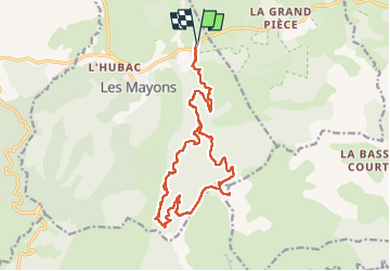

Lengte
20 km

Max. hoogte
657 m

Positief hoogteverschil
621 m
Km-Effort
29 km

Min. hoogte
129 m

Negatief hoogteverschil
621 m
Boucle
Ja
Datum van aanmaak :
2024-05-17 07:00:24.0
Laatste wijziging :
2024-05-17 13:57:05.004

Gratisgps-wandelapplicatie
 SityTrail
IGN / Geografische instituten
SityTrail Plus
De wereld gaat voor u open
Over ons
Tocht van 20 km beschikbaar op Provence-Alpes-Côte d'Azur, Var, Les Mayons. Deze tocht wordt voorgesteld door PhL83.
Plaatsbepaling
Land:
France
Regio :
Provence-Alpes-Côte d'Azur
Departement/Provincie :
Var
Gemeente :
Les Mayons
Locatie:
Unknown
Vertrek:(Dec)
Vertrek:(UTM)
287386 ; 4800037 (32T) N.
Opmerkingen